- Location and arrival
- The Rieselfelder
- The huts
- The seasons
- The equipment
- Conclusion
- Download map of Rieselfelder
The Rieselfelder Münster are located in the north of the North Rhine-Westphalian city of Münster. The Rieselfelder are a bird sanctuary of the European Union, which has emerged
from former sewage irrigation areas.

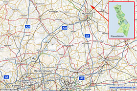
I have attached an overview map on the left for better orientation (for more details, please click on the map). The Rieselfelder can be easily reached via
the A1 motorway. If coming from the north, take the Greven exit (exit 76) towards Münster and follow the "Schiffahrter Damm" for about 8 km until reaching the town of Gelmer. Then
turn left onto "Gittruper Straße" and follow the road for about 1.5 km. After crossing the Dortmund-Ems Canal, turn left onto "Coermühle" and after about 1 km, you will reach the parking
lot of the
Biological Station.

From the south, the Münster-Nord exit (exit 77) offers the shortest route. After that, follow the B54 towards Münster for about 6 km and then turn left onto
"Grevener Straße" (B219). Follow "Grevener Straße" for about 4.5 km in a northerly direction and then turn onto "Coermühle". Follow "Coermühle" for about 2.5 km, and you will reach one of
the parking lots of the Rieselfelder, located directly at the "Heidekrug" restaurant.
In addition to the parking options already mentioned, there is a smaller parking lot at "Wöstebach". To get there, follow "Coermühle" about 1 km east and then turn right onto
"Wöstenbach". There are only 3 to 4 parking spaces available at the E1 reservoir
(see map),
which is located directly at "Coermühle". There is also a parking lot at "Hessenweg". To reach this parking lot, turn onto "Hessenweg" from "Coermühle" towards the Dortmund-Ems Canal.
If you prefer to use a navigator to reach the parking lot at the "Heidekrug" restaurant, enter the following information: "Coermühle 100, 48157 Münster" (Pos@: 7.640231 52.014376).
For the parking lot at the Biological Station, enter the following information: "Coermühle 181, 48157 Münster" (Pos@: 7.655074 52.028793).
(back to the top)

The Rieselfelder have a length of approximately 5 km in the north-south direction and a length of approximately 2 km in the west-east direction. The area consists
of several smaller individual fields, which in turn consist of wetlands, meadows, and bodies of water. Roughly speaking, the "Rieselfelder von Münster" are divided into a nature reserve
located to the north and a nature experience area adjacent to the southeast. Both areas are generally accessible, but there are many areas that are completely closed to the public.
All of the fields have an internal number, and when talking with insiders of the Rieselfelder, these numbers are often given as a location description. In addition to the overview map
on the left, I will also provide a more detailed map for download at the end of this report, which you can print out and hopefully use for better orientation in the Rieselfelder.
The majority of the Rieselfelder can only be crossed on foot, with the central areas of the fields closed to the public. The few drivable roads in the Rieselfelder offer very few
opportunities to take photos from the car. Those who wish to take photos from their car should therefore look for opportunities in the wider area surrounding the Rieselfelder.
(back to the top)

To get right to the point, the opportunities for nature photography in the Rieselfelder are mixed. The animals are not accustomed to humans, even though there
is relatively heavy foot traffic in the Rieselfelder on nice weekend days. The Rieselfelder offer a total of 10 observation huts, which you can view individually by clicking on the
photo on the left. All huts are available free of charge and without registration at any time. Unfortunately, the huts are not specifically designed for nature photographers, but
rather they are better suited for observations with binoculars or spotting scopes. As can be seen in the photos, most of the observation huts are also quite tall and therefore offer
a poor perspective for photography. In addition, the distances to the birds are quite far and the view is often obstructed by overgrown reeds.
You can view a few interior shots of the huts and views from the huts
here.
In addition to the huts, there are also some
observation points
,
that provide additional camouflage. The path from the hut at E1 southwards to the reservoir leads directly to the
observation tower
from which one has a beautiful view over the reservoir.

As mentioned before, the conditions are not optimal, but for those engaged in wildlife photography, such circumstances are not unfamiliar, and it is not as if there
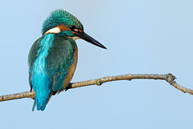
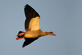
are no opportunities to take pictures. I took the photo of the kingfisher on the right from the hut in field 15. I have written the location of each of the other photos underneath the
respective images. The hut at E1 (Coemühle) offers the closest distance to the birds, but this also depends on the current water level. In addition to using the huts, it also makes sense
to go on foot occasionally. With some luck and skill, one can occasionally get relatively close to some birds.

The best times for birdwatching are the migration periods in spring (early April to mid-May) and autumn (late summer to mid-October). However, there is always
something to observe during the other seasons as well. Current bird count results are displayed at the
Biological Station and the E1/Coemühle
observation hut. During winter months, there are often winter guests (such as Little Grebe, Smew, and Common Goldeneye) that can only be found in the Rieselfelder during the cold
season. Canada, Nile, and Greylag Geese can be observed in the Rieselfelder all year round. Therefore, it is definitely worth visiting the Rieselfelder during the quieter seasons.
(back to the top)
The equipment actually puts itself together on its own through my previous descriptions. As often with bird photography, focal length can only be replaced by even more focal length.
In plain language, this means that at least 500mm should be used on an APS-C camera. In all huts, setting up a tripod is possible, and alternatively, the use of a beanbag is also possible.
For stalking on foot, I would prefer a monopod. Since the path network covers a total of 12 km and the equipment is usually somewhat heavier, I would recommend using a beach trolley for
transport.
(back to the top)
Despite the often not very good conditions for photography, I still recommend a visit to the Rieselfelder. Although there have been many days for me that ended without a usable photo,
but that's not uncommon in nature photography. It is definitely always a beautiful experience and often you also meet other nature photographers with whom you can exchange ideas on site.
(back to the top)
You can download a map of the Rieselfelder here. To view and print it, you will need an Acrobat Reader.
 map of Rieselfelder Münster
written: March 2010, (author: Olaf Juergens)
 print version


