- Location and arrival
- The chalk cliffs
- The views
- Beech forest in Jasmund National Park
- Cape Arkona
- Ghost forests
- The equipment
- Conclusion
- Download map of Rügen
Rügen is the largest German island and is located off the Pomeranian Baltic coast in Mecklenburg-Western Pomerania. The island can be reached by land either via the old Rügen
Dam or via the parallel Rügen Bridge, which was completed in 2007. The Rügen Bridge is a three-lane high bridge that can only be used by motor vehicles and usually provides the
fastest connection to the island.

For better orientation, I have added an overview map on the left (for more details, please click on the map on the left). Rügen has a maximum length of 52 km
in the north-south direction and a maximum width of 41 km. The coastline is characterized by numerous bays and peninsulas, and especially this ruggedness by bays and inlets is part
of the charm of the island of Rügen. In the northeast of Rügen is the Jasmund Peninsula, which is likely to be a major attraction for nature photographers, as it is characterized by
the chalk cliffs and beech forest. The accommodation options on Rügen are quite numerous, and for those who want to stay near the chalk cliffs, I recommend looking for accommodation
in the town of Sassnitz.
(back to the top)

One of the most famous attractions of Rügen is probably the approximately 15 km long chalk cliffs, which extend in the northeast of the Jasmund Peninsula
see map.
At the end of this travel report, you will find additional map material for download to help you better navigate the island. Since the chalk cliffs are located in the northeast,
there is only sunlight on the cliffs in the morning. It is recommended to arrive on site well before sunrise, as the dawn presents the chalk cliffs in a particularly beautiful light.
On the one hand, it is possible to walk along the shore of the chalk cliffs, and on the other hand, it is possible to explore the coast from the top of the cliff. The shoreline is
characterized by a narrow, rocky beach path that offers numerous subjects such as dead trees or small rocks. The high cliff path, on the other hand, leads directly along the cliff
edge through the beech forest. Hiking on the chalk cliffs is not entirely without danger, as there have been repeated collapses in recent years on the chalk cliffs, some of which
rise up to 120 meters. During my visit in the summer of 2011, there had been one of the largest collapses a week before, which was triggered by extreme rainfall in the weeks before.
To get to the beach, there are two options: either go directly from Sassnitz to the shore, or use one of the four descents from the high cliff path. The descents consist of wooden
stairs, some of which have over 400 steps. The easiest ones are the two descents in the Pirate's Gorge (see map at the end of the report), which have less than 100 steps.
(back to the top)

To get to the beach, there are two options: either go directly to the shore from Sassnitz, or use one of the four descents from the cliff-top path. The descents
consist of wooden stairs, some of which have over 400 steps. The easiest ones are the two descents in Piratenschlucht (see map at the end of the report), which have less than 100
steps each. Along the cliff path from the chalk cliffs, there are several noteworthy viewpoints of the rocky landscape. A well-visited attraction is the Stubbenkammer with the
Königsstuhl (King's Chair) National Park Center. From the fee-based parking lot "Hagen", you can hike a 3 km forest path up to the Königsstuhl. Alternatively, there is a bus shuttle service
that goes up to the National Park Center. The road to the National Park Center is only allowed for bus traffic from 9:00 a.m. onwards. Until 9:00 a.m., you can also drive up the road by car,
and if you want to take pictures in good light, you should already be up there by then. From a photographic point of view, you can skip the paid National Park Center because when you are
there, you are already standing on the 118-meter-high Königsstuhl, and essentially only have the view of the Baltic Sea. A much better view of the Königsstuhl can be had from the nearby
Victoria View (see map at the end of the report).
From Königsstuhl, you can continue hiking southward along the cliff path towards Sassnitz and along the way, you'll find magnificent views of the landscape of the chalk cliffs. As I mentioned
earlier, the best time for photography at the chalk cliffs is early in the morning when the sun beautifully highlights the structures of the cliffs, which is how the picture of Königsstuhl
was taken shortly after sunrise.
(back to the top)

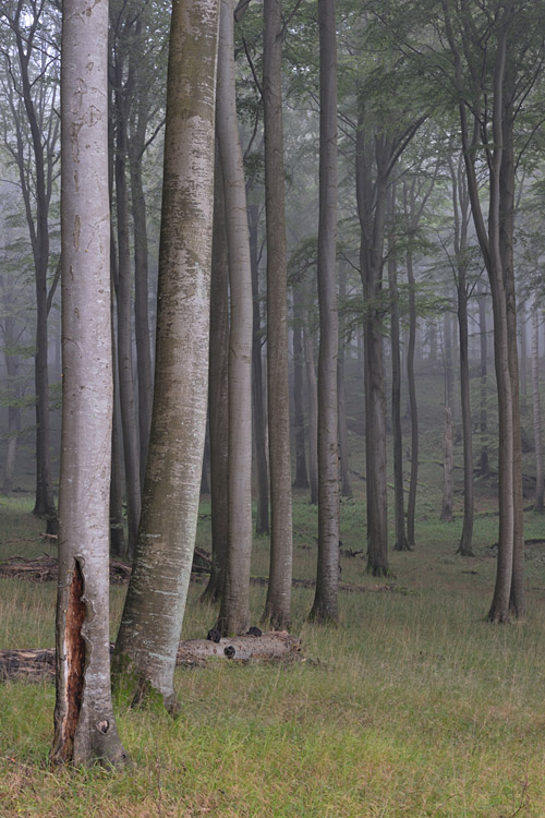
On June 25, 2011, the beech forest of the Jasmund National Park was declared a UNESCO World Heritage Site, and I believe this was fully deserved. The location of the
beech forest makes it a unique forest that offers particularly grateful subjects for nature photographers. Because the forest extends to the cliff, you can, if you're lucky with the weather,
experience a glowing effect of the forest caused by the rising sun over the sea. The forest floor also offers an unusual sight in many places. With its many different grasses, the ground
presents itself as a uniquely green carpet. The whole scenery is underlined by several streams that flow through the forest. I find the area around the Kielbach particularly worthwhile here.
In my opinion, the footpath from the Hagen car park up to Stubbenkammer is also worth it. So, if you forego the bus connection to Stubbenkammer here, you will be presented with a very
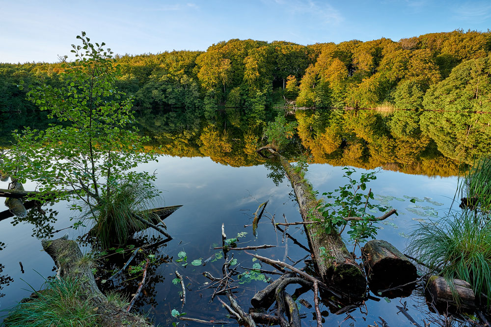
beautiful forest path with many worthwhile motifs. However, you should plan another 30 minutes for the way from the car park up to Königsstuhl. If you combine the ascent with photography,
the time can quickly double or triple :-). Among other things, on the way to Königsstuhl, you pass a very beautiful forest lake, the legendary
Herthasee.
(back to the top)

Translated to English: Kap Arkona is located on the
Wittow Peninsula
in the north of the island of Rügen and is characterized by a 45-meter-high cliff coast. While the best light can be found in the morning at the chalk coast in the Jasmund National Park,
Kap Arkona is also very suitable in the evening. However, the direct route by car to the cape is only open to residents, all others can use a paid parking lot in Putgarten and must then
allow for a walk of about 2 km to the cliff coast. Once you have made it to the lighthouse on the northern tip, you can reach a 230-step staircase via a small footpath, which helps you
to overcome the cliff coast down to the beach. The beach is characterized by coarse gravel stones, similar to the beach at the chalk cliffs. There are several smaller rocks in the water
that can be beautifully incorporated into photos together with the setting sun. If you prefer to photograph at Kap Arkona in the morning, simply walk in an easterly direction at the end
of the staircase and you will be presented with the cliff coast in the morning light.
To the east of the parking lot
see map,
there is an old fishing village called Vitt, which I did not visit myself, but which is said to offer beautiful motifs, according to what I have been told.
(back to the top)

The Ghost Forest at Nienhagen (northwest of Rostock on the Baltic Sea coast) is certainly the most famous ghost forest in the region, but in fact, this type of forest
is more common along the Baltic Sea coast. Therefore, there are also forests on Rügen with trees that are bizarrely bent by the sea wind. The trees (mostly ashes and various beech species)
are shaped by the salty, humid Baltic Sea wind and its storms. Wherever trees have stood directly on the coast for decades, the chance of encountering such mystical tree formations is very
high. Especially in low sunlight or in fog, these forests offer excellent photo opportunities.
(back to the top)
As my travel report about the island of Rügen exclusively focuses on landscape photography, I want to give my recommendation in this direction. However, wildlife photography and macro
photography can also be practiced on Rügen, but I have not tried this yet. For landscape photography, I prefer to use a medium telephoto lens and use a 70-200mm zoom for that. Additionally,
I use a 24-70mm lens for the wide-angle range (all based on full frame). Although I always have an ultra-wide-angle lens with me, I use it for less than 5% of my shots. I would definitely
recommend a set of different gradient filters, a polarizing filter, a neutral density filter, as well as a tripod.
(back to the top)
My conclusion about the island of Rügen is very brief and positive. It is a wonderful island for landscape photographers, which offers a lot of variety and opportunities.
(back to the top)
You can download maps of the island of Rügen here. To view and print them, you will need an Acrobat Reader. I hope the maps will help you navigate the island easily. I highly recommend
a visit to anyone..
 map of Rügen
Written: September 2011, (author: Olaf Juergens)
Updated: September 2020
 print version


