- Location and arrival
- Hiking along the Affenstein Promenade
- The Schrammsteine
- The Bastei
- The Carolafelsen
- Hiking in the National Park
- The equipment
- Conclusion
- Download maps Elbe Sandstone Mountains
The 700 km² large Elbe Sandstone Mountains consist of the German part, which is referred to as the "Saxon Switzerland," and the "Bohemian Switzerland," which is located in
the Czech Republic north of Decín. This travel report is initially about the "Saxon Switzerland," as I only briefly visited the Czech part of the Elbe Sandstone Mountains and
would like to explore it more extensively in the future.

The "Saxon Switzerland" is located in the state of Saxony and is about 40 km southeast of the city of Dresden. To get a better orientation, please click
on the left overview map. In the map, I have highlighted the area of the national parks of the Saxon and Bohemian Switzerland. The Elbe Sandstone Mountains are a highly rugged
medium mountain range that stretches on both sides of the Elbe River. The Großer Zschirnstein, with its height of approximately 560 meters, is the highest mountain in the Saxon
Switzerland. To be as close as possible to the photo spots in the Saxon Switzerland, it is recommended to look for accommodation in the core zone of the national park. Small
villages east of the Elbe are well-suited for this purpose, such as Porschdorf (about 400 inhabitants), Bad Schandau (about 3,500 inhabitants), or the slightly larger town of
Sebnitz (about 10,000 inhabitants).
(back to top)

There are many hiking trails that are described in various hiking guides, and I have chosen a specific hike along the Schrammsteine and Affensteine for my
project, as the trail passes many highlights of the Elbe Sandstone Mountains. The hike is a total of 22 km and for a normal hiking tour, one would have to budget more than 5 hours
for this distance. For an intensive photo tour, this hike is of course far too long, and I strongly recommend not trying to complete the trail in one day. You can divide the tour
into several parts, as there are several parking options along the way. If you want to go to the Schrammsteinaussicht first, I recommend the parking lot on the "Zahnsgrund" road,
which is located above the restaurant "Schrammsteinbaude". If you want to explore the area around the Affensteine and the Carolafelsen first, I recommend the parking lot "Beuthenfall",
which is located near the Kirnitzschtalbahn stop. If you still have time and energy afterwards, you can make a detour to the Great Winterberg.
(back to top)

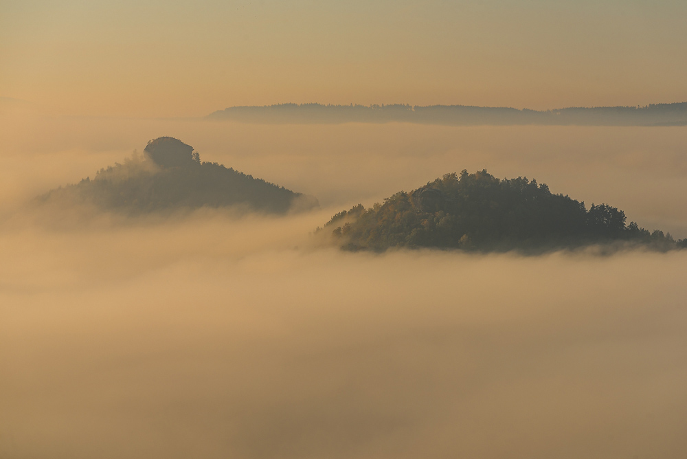
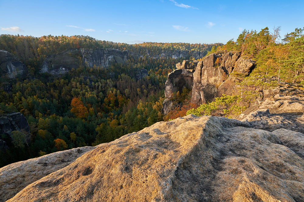
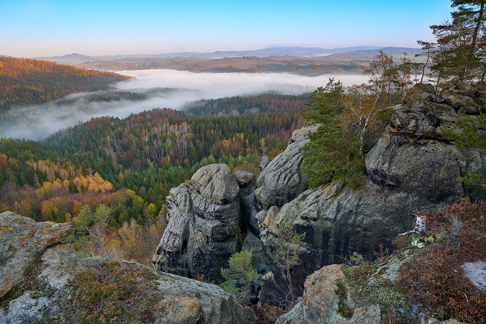
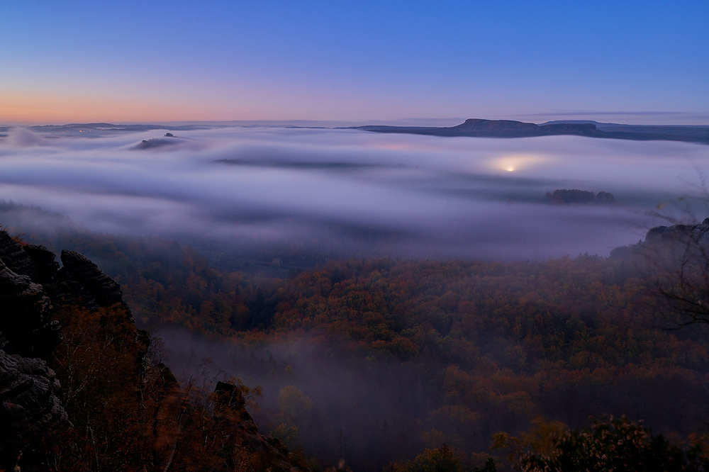
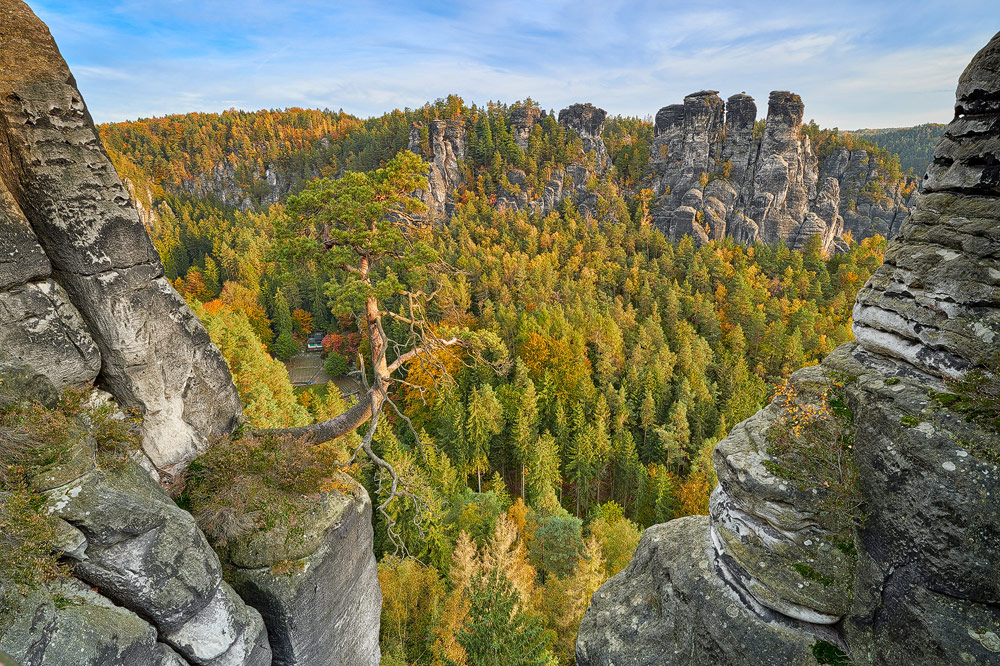
The rock formation of the Schrammsteine is definitely one of the highlights of the Elbe Sandstone Mountains for me, and a visit is particularly worthwhile in good
lighting conditions or when fog has formed in the valley. The hiking trail to the Schrammstein viewpoint is well marked and should be easy to find. Although the path is not particularly difficult,
a certain level of physical fitness is required as the ascent to the Schrammstein viewpoint involves many steps and a small ladder at the end. From the viewpoint, you not only get a view of the
Schrammsteine but also of the
Falkenstein.
The approximately one hundred meter high and free-standing rock serves as a climbing rock for experienced climbers.
(back to top)

The Bastei is probably the most famous attraction of Saxon Switzerland, as nowhere else can you get such a sensational view of the Saxon Switzerland
with such little effort as from the viewing platform of this rock formation. If you want to enjoy the Bastei a bit more peacefully, you should definitely plan a visit
outside peak hours (between 9:00 am - 5:00 pm) and avoid weekends if possible. During peak hours, you have to deal with busloads of tourists, and on the Bastei Bridge, a
pedestrian-only bridge, it's as crowded as on Cologne's Domplatz. Since the best photo light is in the early morning or evening hours anyway, you benefit from another
advantage, because at these times there are usually parking spaces available in the upper parking lot and you save yourself the lower parking lot, which is about 3 km away
and connected to the Bastei by a shuttle service. On the Bastei grounds, you can visit the rock fortress (admission: 2 Euros / as of September 2017), provided you are not
on-site outside of opening hours. In addition to the excavations and reconstructions to be seen there, you have a very nice view and interesting photo perspectives that
result from the rock fortress (
see also map).
(back to top)

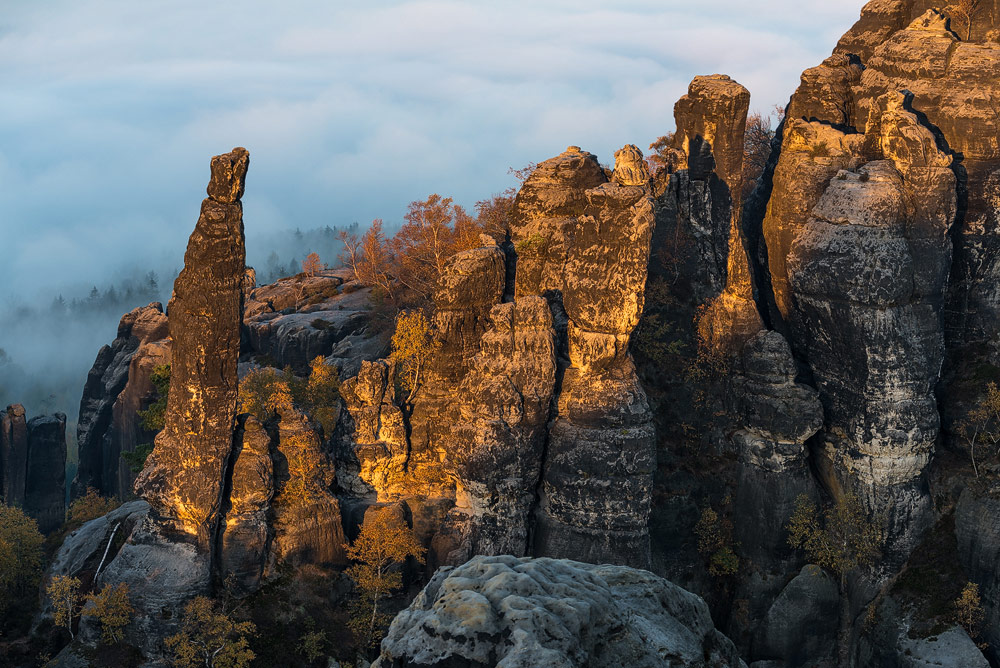
The Carolafelsen belongs to the elongated rock formation of the Affensteine and, at 458m, is the highest point of this rock formation. Especially at sunset,
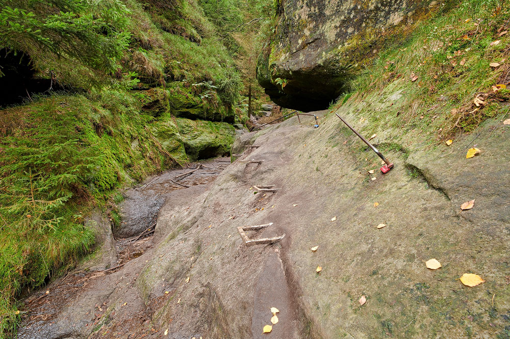
the view from the Carolafelsen over the Elbe Sandstone Mountains is worth seeing. The shortest way to the Carolafelsen leads from the Beuthenfall parking lot through the "Wilde Hölle".
Die
"Wilde Hölle"
is a small gorge that leads to the Upper Affensteinweg via stone steps, ladders, and iron rungs, and requires a little fitness from the hiker, as well as good footwear.
Alternatively, you can also take the detour around the Wilde Hölle to the Carolafelsen.
(back to top)

Hiking in the national park of Saxon Switzerland or Bohemian Switzerland can be quite demanding, especially when carrying around 10 kg of photography equipment
and a tripod. Even though the highest mountain in Saxon Switzerland only reaches a height of 560 m, the elevation gains are often accomplished over a short distance, which usually
means a steep ascent if you want to climb high. Steep stairs, narrow gorges, and even a freestanding 8-meter-high ladder that must be overcome when climbing Winterstein are not
uncommon:
click here.
Of course, one doesn't need advanced mountaineering training to tackle the hiking trails and especially the ascents of the Elbe Sandstone Mountains. However, one should be very
careful in wet and slippery conditions and wear good shoes, as the ladders and stairs can be quite slippery. The hiking trails are otherwise very well marked, and one could even
navigate without a map.
(back to top)
For landscape photography in the Elbe Sandstone Mountains, one should plan to use focal lengths between 14mm and 200mm. I would not want to do without a tripod under any
circumstances. On the one hand, a tripod helps with image composition, and on the other hand, interesting lighting conditions require long exposure times. Also a set of different
gradient filters should not be missing, and a polarizing filter is also useful for many photo opportunities. In addition to the photography equipment, clothing should also be appropriately
designed. Therefore, sturdy hiking shoes with adequate ankle protection are recommended in any case! Clothing should be adjusted according to the season and should be rainproof,
as a rain shower in the mountains is always to be expected.
So far, I have only visited the Elbe Sandstone Mountains in the fall, but I am sure that the area has its charm at any time of the year. A detour to the Czech side in
Bohemian Switzerland can also be recommended, and for those who need a short break from nature, there is plenty of variety in Dresden, which is about 50 km away.
(back to top)
Here, you can download a map of the Elbe Sandstone Mountains. You will need a PDF reader to view and print it. I hope the map will help you to get your bearings in the
Elbe Sandstone Mountains.
 Maps Elbe Sandstone Mountains
written: December 2018, (author: Olaf Juergens)
updated: November 2021
 print version


