- Location and arrival
- The South
- The West
- The North
- The East
- Puffins, the clowns of the sky
- Winter in Iceland
- Driving in Iceland
- Fording rivers, how to do it?
- General travel tips and costs
- The equipment
- Conclusion
- Maps of Iceland
Since I have made a total of seven trips to Iceland so far, with only a limited amount of time available, this travel report is limited to the areas I have visited. I hope to
make further trips to Iceland soon and will gradually add to this report.
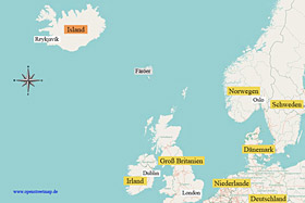
For better orientation, I have attached an overview map on the left (for more details, please click on the map on the left). Iceland has an area of
approximately 103,000 km², which is about the size of the two German federal states of Bavaria and Baden-Württemberg combined. Even more interesting is the low population
density of 3.1 inhabitants per km², as there are only about 320,000 inhabitants in Iceland. If you consider that about 2/3 of the population live in the greater Reykjavík
area, you can imagine that the infrastructure of Iceland is incomparable to any other European country.
The easiest and most comfortable way to reach Iceland is by plane (approximately 3.5 hours flight time from Frankfurt). Iceland's international airport is located near the
small town of Keflavík, which is about 50 km from Reykjavík and well connected by the
Flybus.
(back to the top)

To the southwest of Iceland and north of Reykjavík lies the boot-shaped Reykjanesskagi peninsula. If you drive east on Road 427 in the south of the peninsula, past the town of
Grindavík, you will reach the intersection of Roads 42 after about 25 km, and after about 5 km further you will reach the Krýsuvík volcanic system
(
see map).
I highly recommend visiting Seltún in the high-temperature area of Krýsuvík. In the small area of Seltún, the earth boils and steams from mud pots and solfataras, providing
many photo opportunities. On the way to Seltún, there are several water-filled maars such as Grænavatn or Gestsstaðavatn. If you continue on Route 42 about 3 km north of
Seltún, you will reach Lake Kleifarvatn. The lake, with a length of 4.7 km and a width of 2.5 km, is located in a beautiful mountain landscape.
(back to the top)
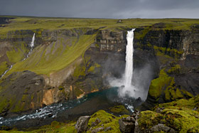
Island offers nearly endless waterfalls, and not a few of them are located in the south of the country. Some very well-known waterfalls are located
directly on Iceland's main road 1. The well-developed main road 1 is a circular route that circles the entire island and has a total length of approximately 1300 km. Many
attractions are located along this ring road and are very easily accessible. The downside of the good accessibility is that one is hardly ever alone there at any time of
day, and at certain times, tour buses arrive every half hour.
If you visit waterfalls outside of the "Golden Circle," you will generally be spared from mass tourism. The "Golden Circle" is the popular route in the south that includes
Þingvellir National Park, the Haukadalur geothermal area with geysers, and the Gullfoss waterfall.
The somewhat remote Háifoss waterfall (with a drop of 122 meters) is located about 70 km from the Ring Road and can be reached via Route 32 and 332
(
see map).
The gravel road 332 is not classified as an F-road (
see driving in Iceland),
and therefore it would be passable with any vehicle. However, the condition of the road is so poor that personally, I would only drive to Háifoss with an off-road vehicle.
After visiting Háifoss, a visit to
Gjáin
(Icelandic: "the canyon"), about 10 km away, is also recommended.
Gjáin is a canyon with many waterfalls and cascades and offers great hiking opportunities.

One of the most famous, spectacular, and beautiful waterfalls in Iceland is Seljalandsfoss (66 m fall depth), which is located directly on the Ring Road
about 20 km southeast of the small town of Hvolsvöllur (
see map).
The special thing about Seljalandsfoss is that you can walk directly behind the waterfall. If you don't stay behind the waterfall for too long, you have a good chance of keeping
yourself and your equipment somewhat dry. A visit at sunset is particularly recommended, if there is a clear sky, because then you can photograph the setting sun behind the
waterfall and the evening sun illuminates the rock. 30 km east of Seljalandsfoss, also directly on the Ring Road, is
Skógafoss (60 m fall depth).
Below the Skógafoss, a small steep path leads up to the edge of the waterfall. Before driving to Skógafoss, a stop at
Eyjafjallajökull is worthwhile, whose volcano
(Eyjafjöll) during the eruption in 2010 brought air traffic over Northern and Central Europe to a standstill. At the visitor center, there is a small exhibition that provides
information about the volcanic eruption and is operated by the family who owns the farm at the glacier.
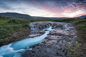
Brúárfoss is for me one of the most beautiful waterfalls in Iceland and I have visited this extraordinary waterfall with its turquoise water in all
seasons. Brúárfoss is located about 15 km southwest of Geysir Center on Route 37 in a holiday home development. Unfortunately, in 2018, tourists misbehaved in the area, so
the landowner has now completely blocked access to the waterfall. The year before, you could still hike to the waterfall on foot. However, even that was a restriction as in
previous years, you could drive pretty close by car. Brúárfoss was once a real insider tip before the masses of tourists were directed there through blog posts. Until the
blockade, I had refrained from posting directions on the internet because this area simply cannot tolerate hundreds of tourists a day. Perhaps the situation there will
change someday, but it doesn't look like it at the moment.
Going off from the Ring Road, you can reach the Gullfoss waterfall by taking the road 30 in a northerly direction for about 60 km.
The
Gullfoss
is a fairly frequently visited waterfall that impressed me mainly due to its enormous amount of water, which plunges over two cascades into a depth of 70 meters.
From a photographic point of view, however, I did not find the Gullfoss very exciting. If you drive to the Gullfoss, you are also very close to Iceland's most active
geyser, Strokkur. To get to
Strokkur
, you drive the road 35 about 10 km in an eastern direction. You don't have to wait long for the show, because the geyser spits its 25-30 m high and hot water column
into the air after at most 5 minutes.
(back to the top)
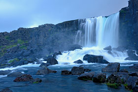
The Thingvellir National Park is located about 40 km east of the capital Reykjavík and is easily accessible via Route 36
(
see map). This place is
historically significant for Iceland, as the republic was founded here, among other things, and also geologically interesting, as it shows the drifting apart of the
American and European tectonic plates. Huge rock clefts and cracks are visible in many places, through which one can sometimes walk. The Öxarár River winds its way
through the national park, and in the Almannagjá gorge, it houses the very beautiful Öxarárfoss waterfall. As the Thingvellir National Park is one of the most famous
sights in Iceland, unfortunately, one also has to expect a lot of tourism on site!
(back to the top)

The small town of Vík í Mýrdal is located right on the beach, whose sand is made of black lava and is one of the 10 most beautiful beaches in the world.
From the beach, you have a beautiful view of the famous rock formations, the Reynisdrangar, which rise out of the water and are said to represent petrified trolls. The Reynisdrangar
rocks can be accessed from two different locations
(see map).
As the beach is not continuously accessible due to a rock wall, it is best to use both parking lots west and east of Reynisdrangar to approach the motif from two perspectives. At this point,
I would like to draw attention to a deadly danger at the beach of Reynisdrangar. There are always
monster waves
on this beach, which have already caused several fatal accidents in the past. The waves are unpredictable and the beach cannot be compared to the usual shallow beaches in southern Europe.
Due to the fact that this beach drops off quite quickly, extremely high waves are constantly forming. Even if you have only been observing a small surf on the beach for half an hour,
you will be amazed at the enormous force suddenly unleashed by a high wave. Finally, in February 2016, a Chinese tourist died on the beach of Reynisfjara, and in January 2017, a German
tourist died at the Kirkjufjara beach section due to a large wave. So please do not ignore the warning signs on the beach and do not go too close to the water to avoid more fatalities
at this beach!!!
Not far away to the east of Reynisdrangar is the
Dyrhólaey peninsula,
which rises about 115 meters steeply out of the water. Dyrhólaey is the southernmost point of Iceland and can be reached from the Ring Road 1 via Route 218.
The last stretch is driven on a gravel road which ends at a parking lot and from which everything is easily accessible on foot. Between spring
and summer, puffins can be photographed well at Cape Dyrhólaey. However, the area is partially closed during the breeding season. It should also be considered
that the whole area around Vik can often be very windy and wet!
(back to the top)
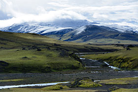
Some people claim that the true Iceland begins in the highlands. I wouldn't go that far, but from my point of view, traveling to Iceland
without visiting the highlands would be a mistake. However, driving in the highlands requires using a vehicle with all-wheel drive. There is also the option to
explore parts of the area with a special highland bus. Four-wheel-drive vehicles are not only advisable but mandatory in the highlands! I have described everything
to consider when driving in a separate section called
"Driving in Iceland"".
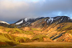
A special experience is the Landmannalaugar area, which is located near the active volcano Hekla. Incredibly vibrant colors, hot springs,
moss-covered lava rocks, rising steam, and lakes await you in this section of the highlands. Landmannalaugar can be reached via the F208 road, provided the road
is passable, as most highland roads are completely closed in winter and usually also into spring. So, before heading to the highlands, it is advisable to check
the current road conditions:
www.road.is. You can reach the F208 from
the south via the Ring Road and then take the F224 to Landmannalaugar.
The second option is to approach Landmannalaugar from the north via the F224 road and the F208 road:
see map. At the end of
the F224 road, you will reach the
base camp
of Landmannalaugar, from which many hiking trails start.
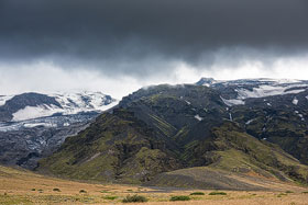
To the south and north of Eyjafjallajökull is the mountain ridge of Thorsmork. Thorsmork is a rocky area that gets its name (Icelandic Forest of Thor)
from the wooded mountain ridge. Thorsmork can be reached by driving from the Ring Road at the Seljalandsfoss waterfall onto the Route 249
(
see map). The Route 249 becomes
an F-road shortly afterward and can only be driven with an all-wheel-drive SUV. To get to the Thorsmork mountain ridge, you have to pass various fords because the area is
between the Krossá þröngá and Markarfljót rivers. Depending on the water level, the fords can be quite deep, and you should have an appropriate vehicle, especially since
crossing the Krossá ford may require a vehicle with high wading depth (see tips for fording).
(back to the top)
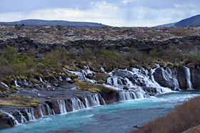
The Hraunfossar waterfalls are located in the west of Iceland, about 3 km west of the small town of Húsafell
(
see map). The small waterfall
Barnafoss is in close proximity. The Hraunfossar flow for several hundred meters from a lava field into the Hvítá river, which is fed by the "Langjökull" glacier. The
phenomenon of the waterfalls emerging from the rock is explained by a tributary of the Hvítá river flowing underground until it finally flows out of the lava rock, thus
forming the Hraunfossar. If you drive back towards the west from the Hraunfossar, it is worth taking a detour via the 522 or 527 to the
Grábrók crater.
The largest of the three craters can be climbed, and from the top, there is a very nice view over the crater landscape.
(back to the top)
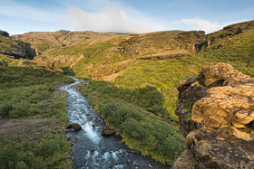
The waterfall Glymur is located about 40 km (as the crow flies) south of the Hraunfossar
(
see map).
With a drop of approximately 196 meters, Glymur is the second-highest waterfall in Iceland. You can reach the waterfall by not driving through the approximately 5.7 km
long toll tunnel Hvalfjarðargöng, but instead taking the scenic route on Route 47, coming from the Ring Road. Once you reach the westernmost tip of the fjord on Route 47,
the path leads to a parking lot, and from there, it's a hike towards the waterfall. You should plan about 3 hours for the approximately 6 km long hiking trail (round trip).
The path is quite challenging as you walk through a small cave, cross the river on a wooden beam with a wire to hold onto, and the ascent is steep in places.
If you're reasonably fit and take the necessary time, the hike should not be a problem. I have some photos of the hiking trail here:
Click
(back to the top)

Snæfellsnes is a long peninsula in the west of Iceland
(
see map). The peninsula is often
referred to as "Little Iceland" because Snæfellsnes, in terms of landscape, is a miniature version of Iceland. On this small peninsula, one can find waterfalls, lava fields,
cliffs, and at the western end of Snæfellsnes, the 1446 m high volcano Snæfellsjökull, covered by a glacier. The road 570 runs north-south along the volcano, but it is often
difficult to pass and is frequently closed due to weather conditions, even in June.
To drive along the coastline of the peninsula, one should plan for about 250 km of driving, and if one wants to experience Snæfellsnes not just from the car, I recommend
planning for a two-day trip. On the southern side of Snæfellsnes, a visit to the
church in Búðir is worth it, located on Route 54.
If you follow the road 574 further about 20 km to the west, you will reach the small fishing village of Arnastapi. The rocky coast with many different coves and caves is worth
seeing. The most famous is the rock
arch of Arnastapi.
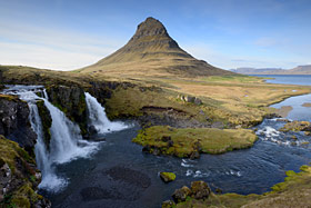
About 2 km west of the small town of Grundarfjörður is the probably most photographed mountain in Iceland, Kirkjufell. The name of the 463 m high mountain
s derived from its church-tower-like shape, as Kirkjufell translates to Church Mountain. The mountain is particularly beautiful when combined with the Kirkjufellsfoss waterfall,
which is only a few meters from Route 54.
(back to the top)

Before heading towards the Westfjords, it is advisable to check the weather forecast and road conditions. Often, some roads are still impassable even in May.
As the roads in the Westfjords consist mainly of gravel, they can become very muddy and soft in case of heavy rain or sleet. The Westfjords are often skipped by most tourists who
plan a round trip in Iceland. The reason for this is probably the almost endlessly rugged coastline, which only allows for very slow progress in the Westfjords. In my opinion, the
sparsely populated Westfjords are definitely worth a visit, but one should plan enough time and maybe also need a bit of luck with the weather, which is often rainy and stormy in
the Westfjords. A popular destination is the Dynjandi waterfall, which can be reached from the south via road 60
see map). The waterfall impresses with a
height of about 100 m and a width of 60 m in the lower area.
Another worthwhile destination is the peninsula of Látrabjarg, located in the furthest west of the Westfjords. Látrabjarg is known for millions of seabirds, including the charming
and popular puffins. I will discuss the photographic possibilities of puffins later in the report. A unique feature of the Westfjords is the northernmost Hornstrandir peninsula.
The remote Hornstrandir is a nature reserve that can only be explored on foot. The best way to reach Hornstrandir is from the town of Ísafjörður, from which a small family business
ferries wilderness-hungry hikers. There are also good chances to encounter Arctic foxes on Hornstrandir, as they are not hunted in the reserve.
(back to the top)
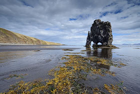
The 15-meter-high basalt rock Hvítserkur is located on the east side of the Vatnsnes peninsula
(
see map), which is easily accessible via the
Ring Road 1. The mountainous Vatnsnes peninsula can be circumnavigated on an 87 km long gravel road. On the west coast in the south is the town of Hvammstangi with a worthwhile seal museum.
If you drive to the northern tip of the peninsula, you will reach the abandoned farm Hindisvík and a bay where a seal colony can be observed. To get to the basalt rock Hvítserkur, follow
the road 711 about 9 km further south. The rock, which resembles an elephant in shape, stands just a few meters from the coast. At low tide, you can walk directly to the rock if you have
mastered the short, somewhat steeper descent from the cliff.
When circumnavigating the Vatnsnes Peninsula, there are many great opportunities to photograph
Icelandic horses.
Of course, the horses can be seen all over Iceland, but on the Vatnsnes Peninsula, there are particularly beautiful backgrounds and the car traffic is not as hectic as, for example, on the Ring Road.
(back to the top)
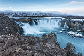
Goðafoss, the waterfall of the gods as this beautiful waterfall in the north is also called. The Goðafoss is easily accessible as it is located directly on the Ring Road
about 50 km west of the port city of Akureyri, which with around 17,000 inhabitants is also the largest population center in the north
(
see map).
You can approach the waterfall from two sides or also reach the other side via a
pedestrian bridge.
Depending on the water level and, of course, individual climbing skills, it is possible to climb down to the waterfall. The Goðafoss has a waterfall height of only 12 meters, and once you reach
the bottom, you get completely new perspectives.

As the Goðafoss waterfall receives its water masses from the Skjálfandafljót River, about 40 km south and upstream, there is another impressive waterfall, the Aldeyjarfoss,
which is fed by the same river as the Goðafoss. To reach the Aldeyjarfoss, departing from the Ring Road, one should follow the 842 road in a southern direction
(
see map). The last 3.5 km to the waterfall can only
be accessed via an F-road (F26). Since an F-road can only be passable with a four-wheel-drive vehicle and it is not uncommon for the F26 to be completely closed until the end of May, there is
still the option of walking the last 3.5 km on foot. Upon arrival, visitors will be greeted by a unique waterfall that plunges its water masses to a depth of about 20 meters. A small circular
basin of red-brown basalt columns provides the incredible sound that this waterfall continually produces.

Not very far from Goðafoss, approximately 100 km drive, is the Dettifoss waterfall. The waterfall can be reached via the Ring Road, continuing eastward past the Mývatn
region and then driving north on Road 862. Instead of Road 862, the Dettifoss can also be reached via Road 864, which is located slightly further to the east
(
see map). Weather conditions may determine which
of the two roads is chosen, as Road 864 is often closed due to impassable conditions until the end of May. On the other hand, Road 862 was recently paved and is usually very passable. However,
there is a downside to choosing Road 862, as it approaches the Dettifoss from the west side, while the east side offers a more beautiful view of the waterfall.
With its drop of approximately 100 m, the Dettifoss is the most powerful waterfall in Europe. Usually, the Dettifoss presents a grey-brown water mass, but when the water flow of the glacier river
"Jökulsá á Fjöllum" is lower, a beautiful blue color can be seen. Located very close to the Dettifoss, about 300 m upstream, is the also worthwhile
Sellfoss waterfall.
(back to the top)
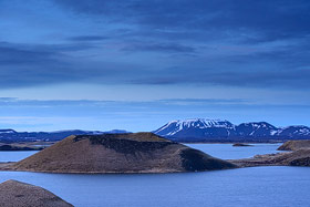
The Mývatn can be easily reached via the Ring Road and is located approximately between Goðafoss and Dettifoss
(
see map). Mývatn translates to "Midge Lake" and,
starting in June, the name becomes fitting as the region with stagnant water and frequent calm winds attracts midges. Although not all midges bite, such as the harmless non-biting midges,
the pests can be very annoying. Fortunately, the midges also attract countless migratory birds and duck species to the lake. The lake covers an area of approximately 37 km² and in summer,
with its shoreline and vegetated crater islands, it appears like a small green oasis in the midst of a barren crater and lava landscape. The Mývatn can be completely circumnavigated by
car and walking paths lead to the rugged shoreline of the lake in many places.
On the east side of the lake, you can reach the impressive
Hverfjall crater
via Route 848.
Hverfjall, which belongs to the Krafla volcanic system, can be climbed (90-150 m height), and a path leads around the 1 km long crater rim. Also accessible from Route 848 and in the immediate
vicinity of the Hverfjall crater is the lava field
Dimmuborgir.
The lava rocks of Dimmuborgir look like abandoned castle ruins. This bizarre environment can be explored on hiking trails, for example to investigate Icelandic mythology, which claims that
elves and trolls live there ;-)
Near the crater and accessible via the road 860, is the small cave
Grjótagjá.
The cave is very small, with only a few square meters of space where one can hardly stand upright. Inside the cave, there is a small, blue shimmering lake with a water temperature of around 45
degrees Celsius. Right in front of the entrance to Grjótagjá, visitors are confronted with a
warning sign that entering the cave is at
their own risk.
(back to the top)
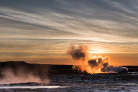
Folgt man vom Mývatn der Ringstraße etwa 5 km östlich, so erreicht man auf der rechten Seite das Hochtemperaturgebiet Hverarönð.
(
siehe Karte).
Hverarönð liegt östlich des 482 m hohen Berges Námafjall (Bergwerksberg). Dieser Berg ist ein aktiver Vulkan und rund um den Berg
befinden sich noch weitere Hochtemperaturgebiete. Am Námafjall gibt es zahlreiche so genannte Solfatare. Diese Solfataren pusten einen Mix aus Wasserdampf,
Schwefelwasserstoff und Kohlendioxid aus und sind die Hauptursache für den schwefelhaltigen Geruch, der sich über das ganze Gebiet zieht. Die
schwefelige Säure, die durch die Solfatare gebildet wird, greift Stein und Boden an und es bilden sich Schlammtöpfe in denen es zu Blasenbildung kommt.
Hier bieten sich in Hülle und Fülle diverse Motive an!
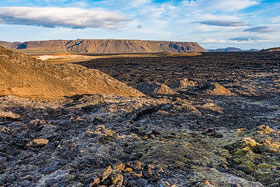
North of Námafjall, the road 863 branches off from the Ring Road and leads to Leirhnjúkur after about 8 km
(
see map).
Leirhnjúkur is an active volcano and is part of the Krafla volcano system, which is about 100 km long. The last eruption series of Krafla took place in 1975
and lasted with interruptions until 1984. From the summit of Leirhnjúkur, you have an impressive view into the caldera of Krafla. Everywhere, you can still
discover the eruption traces of the volcano in the form of heat, solidifying magma, and steam. I recommend planning 2-3 hours to explore the area.
Just 1 km north of Leirhnjúkur is the Víti Lake. Víti means Hell in Icelandic, and it is a maar, a funnel-shaped depression formed by a steam explosion.
The lake has a diameter of about 300 m. However, as there were hurricane-like conditions during my last visit to the crater rim, I cannot provide a photo here.
(back to the top)
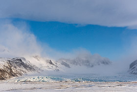
In 1967, the Skaftafell National Park was founded and has since been merged with the Vatnajökull National Park. The Vatnajökull National
Park was established in 2008 and includes the entire Vatnajökull glacier and its adjacent areas
(
see map). In addition
to the glacier lagoons and the waterfall Svartifoss, which I will discuss in more detail below, a visit to the glacier tongues of Vatnajökull is worthwhile. A
good overview of the national park can be obtained at the visitor center in Skaftafell. The glacier tongues are easily accessible from Skaftafellsjökull or
further west from Svinafellsjökull. For those who want to venture deeper into the glacier, guided glacier hikes are offered practically year-round.
(back to the top)
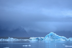
From Skaftafell National Park, it's only about 60 km to the Jökulsárlón Glacier Lagoon. Simply continue on Route 1 to the east to reach the glacier
lagoon (
see map).
Jökulsárlón is Iceland's most famous glacier lake and lies at the foot of Iceland's largest glacier, Vatnajökull. At the same time, Jökulsárlón is also Iceland's deepest
lake (248 m). Those who are lucky enough to experience the glacier lake in good light can expect a dreamlike scenery with smaller and larger icebergs floating on the lake
and providing plenty of photo opportunities with their color differences. Additionally, smaller pieces of ice are often washed up on the black lava beach and can be
beautifully captured in photos. The whole scene is rounded off by some seals that are frequently seen in the glacier lake. About 3 km southwest of Jökulsárlón is the
smaller
Fjallsárlón lagoon, which is also worth a visit!

On the other side of the road, opposite the glacier lagoon, there is a black sand beach called the Diamond Beach. The icebergs floating on the glacier
lake come from the glacier tongue Breiðamerkurjökull and are carried by the currents into the open sea. The ocean surf, in turn, causes small ice floes to be pushed back onto
the beach. There are very nice photo opportunities on the beach and it's worth a visit. The exact location and number of ice floes washed up on the beach depend on the
respective currents and surf.
A bit further west and very close to Jökulsárlón there are two more glacier lagoons (Fjallsárlón and Breiðárlón) which are also worth visiting! About an hour's drive east of
Jökulsárlón and near the town of Höfn, you'll find the
Stokksnes peninsula.
From there, you have a beautiful view of the Vestrahorn, which is part of the mountain Klifatindur.
(back to the top)
If you follow the Ring Road 1 about 140 km east of Vík, you will reach the turnoff to Road 998, which leads to the waterfall "Svartifoss". The Svartifoss
is located in Skaftafell National Park and at the beginning of the hiking trail to
Svartifoss, there is a campsite and an information center
see map). At Svartifoss, the
hexagonal basalt columns are very beautiful to see, which can be observed in many places in Iceland. This form of basalt columns is formed by the slow cooling of lava.
Below Svartifoss are the two smaller waterfalls "Magnusfoss" and the Hundafoss, which are also worth a visit.
Further to the east of Iceland and about 30 km southwest of the small town of Egilsstaðir, you can find the two waterfalls, Hengifoss and Litlanesfoss
(
see map). A steep path leads
directly from the parking lot on Route 933, first to
Litlanesfoss
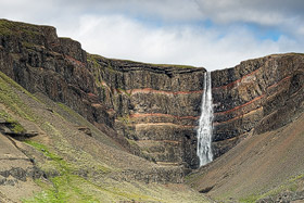
and then to Hengifoss. Overall, you should plan for about 1 hour for the hike to Hengifoss. Hengifoss is Iceland's fourth-highest waterfall, with a drop of 118 meters, and is also
noteworthy for its background, where fine red sediment stripes run through dark lava layers..
(back to the top)
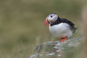
Puffins (English) or Lundis (Icelandic) are also known as clowns of the sky. There are several million pairs of these cute and unshy birds in Iceland. If you want
to photograph them, you should try your luck in Iceland between April and August, as during the other months, puffins exclusively live at
sea.
As puffins prefer to nest on steep cliffs during their breeding season, and there are plenty of those in Iceland, there are many places to observe and photograph these popular birds. I
would like to describe two well-known locations that are particularly suitable for photographing puffins in more detail.
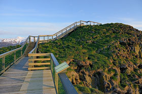
One location is the town of Bakkagerði in the Borgarfjörður municipality on the east coast of Iceland
(
see ma). At the end of Route 947, you can
easily find the tiny harbor of Bakkagerði. At the harbor, there is a small hill with the breeding burrows of the puffins. You can climb the hill via a wooden staircase, which allows
you to get very close to the puffins. Even though you are not allowed to leave the staircase, there are plenty of opportunities to photograph the birds at eye level. By the way,
the puffins only fly in during the evening; during the day, they typically remain on the northern sea.
Another popular location for photographing Puffins is the cliff coast of Látrabjarg, located in the Westfjords and also the westernmost point of Iceland
(
see map).
Látrabjarg is not only known for the Puffins, but is one of the largest bird cliffs in the world and home to millions of seabirds.
In contrast to the location in Bakkagerði, one can move quite freely along the cliff coast of
Látrabjarg.
To be able to photograph the Puffins at eye level, one has to wait for the birds to settle on the edge of the cliff, which fortunately they do quite often.
In addition to the many opportunities for encountering puffins on the steep cliffs, it is also worth mentioning the well-known location at
Dyrhólaey in the south.
However, there are large barriers in place during the breeding season, so I wouldn't recommend this location as the first choice for photographing the birds.
(back to the top)
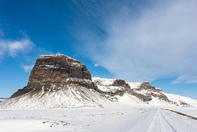
Winter in Iceland is definitely a special time, as even during the other seasons, the weather is unpredictable, but in the winter, you never know what to
expect. From heavy storms, massive amounts of snow, gray rainy days, to beautiful sunshine, anything is possible. In any case, be prepared for the fact that driving a car is not
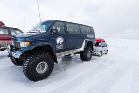
always possible. Winter can start as early as October and last until April. The highlands are then closed and can only be driven in parts with super jeeps. It is therefore
recommended to plan a flexible itinerary and to always plan for an extra day or two to avoid missing the return flight. The roads are usually not salted and only irregularly
cleared. I recommend an off-road vehicle for winter, but an SUV is also sufficient, as it has the appropriate ground clearance and does not get stuck so quickly. Spikes on the
tires (especially in the north) are more than advantageous, but unfortunately not mandatory, so I would advise asking the car rental company in case of doubt. And while we're on
the subject of spikes, it's also advisable to have them on your shoes, as neither walkways to tourist attractions nor accommodations are usually salted in winter.
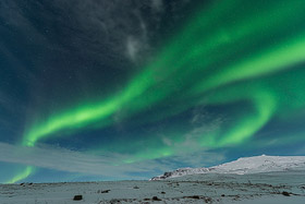
The winter months are also perfect for photographing the Northern Lights. However, a bit of luck is required because a clear sky is a prerequisite, and even
then, the auroras are not guaranteed. In winter, you can also take the opportunity to visit an
ice cave.
Accessing an ice cave is practically only possible with a guided tour because you first have to go quite a distance into a glacier, which is usually only possible in winter with
special Super Jeeps. Ice cave tours are offered in the area of the Skaftafell National Park in the southeast until around March.
(back to the top)
For someone who is dealing with car rental in Iceland for the first time, it quickly becomes apparent that this topic is not as easy to handle as it would be in
other holiday destinations. This is due, among other things, to the extremely high prices for rental cars in Iceland and to the fact that the road and weather conditions on the island
can vary greatly. So, what kind of car do you need? First, I would answer the question of whether an all-wheel-drive vehicle is necessary. There are very different
road surfaces
in Iceland.
It starts with well-paved roads, like most of the Ring Road, and ends with roads that can only be tackled with an all-wheel drive off-road vehicle. In particular, in the highlands,
all-wheel drive is mandatory because there are paths that can only be passed by crossing some fords. A 4x4 off-road vehicle is necessary and even mandatory on all roads marked as
F-roads. Generally, highland roads are not allowed to be driven on with a simple car and this is not recommended! Even in winter, which can start in October and often doesn't end
until May in Iceland, an all-wheel drive vehicle can be very useful. If you don't want to visit the highlands with a rental car and your trip doesn't fall into the winter months,
a simple car without all-wheel drive is sufficient for Iceland. If flexible overnight stays in the car are desired, mini-campers or motorhomes are also suitable for the trip.
In any case, the campers and motorhomes should have a heating system, as even in summer the nights can get very cold.
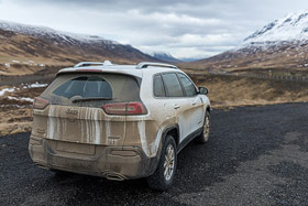
Besides the dangers that lurk when crossing a riverbed, there are other things to consider when driving in Iceland. Iceland has a lot of narrow curves and
hilltops that are not or only slightly visible. Those who drive too fast here may have unpleasant contact with one of the many Icelandic sheep, as the sheep do not follow traffic
rules ;-). Another good piece of advice is to always hold the car door firmly when getting in or out and otherwise keep the door closed, as Iceland has extreme gusts of wind and
it would not be the first time that a car door was torn off in Iceland.
A navigation system in Iceland is quite helpful, but most GPS software manufacturers do not have Iceland in their program. I use a GPS device from Garmin and there is free map material
available here:
click.
The map, however, is not routable. The maps from Ferðakort (scale 1:250,000), available for five different regions in Iceland, have also proven to be reliable.
An official brochure on the topic of "Safe Driving in Iceland" with all marked F-roads can be found here:
click.
(back to the top)
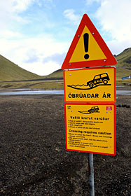
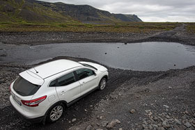
Crossing a ford is certainly the most exciting part of driving in the highlands. Especially as a beginner, one should approach the matter with the corresponding
respect and, in case of doubt, retreat. As already mentioned, water damage is not covered by anyone's insurance, so everything is at your own risk. The fords can have very different
water levels and these often fluctuate even within a day. So if you crossed a ford very easily in the morning, it does not mean that the return journey in the evening will work just as
well. Unfortunately, it is not always possible to determine exactly how deep a ford is, because if the water is dirty, you will not be able to see the bottom. In case of doubt, you can
of course first cross the ford on foot, as long as you are not deterred by cold water on your legs. Alternatively, you can also wait until another vehicle passes the ford in front of
your eyes, because perhaps the driver is on the way back, knows the ford, or simply has no fear. So if you know roughly how deep the ford is at its deepest point, the next look should
be at your own vehicle. Simple SUVs with all-wheel drive often have a manufacturer-approved wading depth of only 40 cm, which is not enough for many fords. Only the large off-road
vehicles (e.g. Land Rover Defender or Discovery, Toyota Land Cruiser, or Jeep Grand Cherokee) or even the modified super jeeps make it possible to tackle more difficult passages in the
highlands. In addition to the depth, the ground conditions and water flow can also be decisive.
Iceland is certainly one of the most expensive travel destinations on this planet, and the financial crisis from 2008 to 2011 did not change that much. This is
particularly noticeable when you want to rent a car. For a larger SUV, you can easily pay 1000 euros per week during the high season. The prices for accommodation, as with car rentals,
depend heavily on the time of year. From May 31st to August 31st, it is high season in Iceland and prices skyrocket during this period. During the high season, it is also advisable to
book your accommodation in advance. As mentioned at the beginning, Iceland is very sparsely populated, so the infrastructure is not very well developed. Although there are plenty of gas
stations in populated areas, it can happen that there is no larger supermarket in some places, and supplies have to be purchased from the convenience store of a gas station. In these
small stores, don't be surprised if a pack of toast costs 3 euros!
(back to the top)

Iceland is certainly one of the most expensive travel destinations on this planet, and the financial crisis from 2008 to 2011 did not change that much. This is
particularly noticeable when you want to rent a car. For a larger SUV, you can easily pay 1000 euros per week during the high season. The prices for accommodation, as with car rentals,
depend heavily on the time of year. From May 31st to August 31st, it is high season in Iceland and prices skyrocket during this period. During the high season, it is also advisable to
book your accommodation in advance. As mentioned at the beginning, Iceland is very sparsely populated, so the infrastructure is not very well developed. Although there are plenty of
gas stations in populated areas, it can happen that there is no larger supermarket in some places, and supplies have to be purchased from the convenience store of a gas station. In these
small stores, don't be surprised if a pack of toast costs 3 euros!
(back to the top)
The equipment is primarily oriented towards landscape photography, so I recommend wide-angle lenses and a medium telephoto lens or zoom lens. I would also suggest including the usual
filters for landscape photography, such as graduated neutral density filters, polarizing filters, and neutral density filters. Those who want to take animal photos should of course plan
for larger telephoto lenses. And, of course, a stable tripod should not be missing.
(back to the top)
Iceland, the land of fire and ice, is one of the most beautiful countries I have ever traveled to. The landscapes are very diverse and fascinating at the same time. When I arrived
on this island on my first day, I was so amazed that I almost forgot to take pictures. I am sure that many exciting trips to Iceland will follow.
(back to the top)
You can download maps of Iceland here. To view and print them, you will need a PDF reader. The maps are intended for rough orientation.
 Download maps Iceland
written: October 2013, (author: Olaf Juergens)
updated: August 2018
 print version


