- Location and arrival
- The infrastructure
- The hotspots
- Haukland and Utakleiv Beach
- Flakstad and Vikten Beach
- All the way in the south
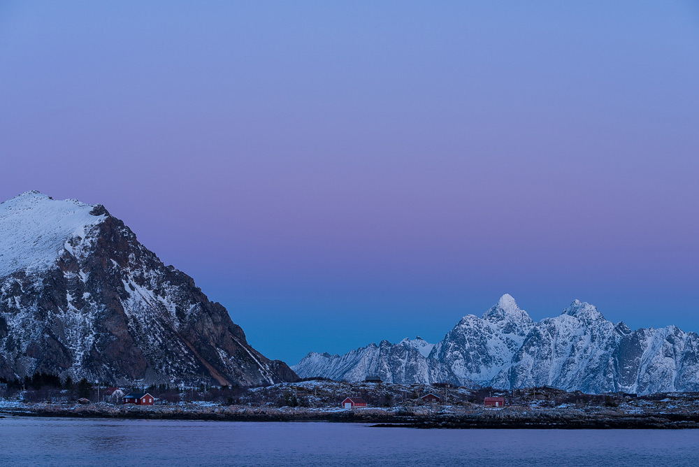
- Winter on the Lofoten Islands
- The costs
- The equipment
- Conclusion
- Maps of Lofoten Islands
The Lofoten Islands consist of an archipelago that is approximately 190 km long and consists of around 80 islands located in the north of Norway. The largest
islands of the Lofoten, in order of size, are Austvågøya, Vestvågøya, Moskenesøya, Flakstadgøya, and Gimsøya. In total, the Lofoten Islands have a total
area of 1227 km².

For better orientation, I have attached an overview map on the left (for more details, please click on the map). If you want to travel
to the Lofoten Islands for the purpose of nature photography, you basically have the choice between traveling by your own car or by plane. If you choose to travel
by your own car, you will also need to take two ferry connections. Although it is possible to use the Øresund connection between Denmark and Sweden, it does not
necessarily save time or money, so I cannot recommend this route. Overall, you should plan 2-3 days for the journey to the Lofoten Islands by your own car, and
that's just for the one-way trip! The choice of ferry connection for the journey to Norway should also depend on your place of residence. One possible connection
is the ferry between Kiel and Oslo, which, in my experience, is the most comfortable ferry connection because you have an overnight stay on the ship and can
continue your journey rested in Oslo. Alternatively, there is also the connection between Kiel and Gothenburg, or from Puttgarden to Rødby, where you then enter
Norway via Sweden. I have provided an overview of all ferry connections in this drawing:
click.
The much faster way to get to the Lofoten Islands is by plane. Flights, for example, are offered from Frankfurt via Oslo to Bodø. The journey from the mainland to
the Lofoten Islands can then be made either by plane or by ferry. There are two airports on the Lofoten Islands in Svolær and Leknes, which are served by the airline
Widerøe. The approach to the Lofoten Islands is very attractive in good weather
conditions, but the ferry connection is also worthwhile. Especially in the off-season, it is advisable to take a closer look at the
ferry schedule in advance to avoid unnecessary waiting times during
the journey.
(back to the top)

On the Lofoten Islands, there are around 24,000 inhabitants, which means that the archipelago is sparsely populated, similar to the rest of Norway.
However, there are ample accommodation options, and visitors can choose between campsites, which often also offer small cabins, hotel rooms, and holiday homes. For those
who want even cheaper options, there are a total of four youth hostels, called "vandrerhjem" in Norway, available on the Lofoten Islands. These hostels are open to all
travelers regardless of age, and with an international youth hostel card, one can get an additional 10% discount on accommodation. Additionally, there are numerous hostels
on the Lofoten Islands. Of course, there is also the option of wild camping based on the "right to access" rule. However, there are fixed rules for the "right to access"
that one should inquire about beforehand. If the camping spot is not part of any property, not fenced, and a few hundred meters away from a settlement, then staying
overnight with a tent for one night is not a problem.
The best way to get around on the Lofoten Islands is by your own car or rental car. While there are also public transportation options, many buses only run 1-2 times per
day and during school holidays, buses run even less frequently. All of the islands of the Lofoten are connected to each other by toll-free
bridges
or tunnels. The main road on the Lofoten is the 170 km long European Route E10 (E10), which begins in the south at the town of Å and ends in the north of the Lofoten in the
town of Fiskebøl.
(back to the top)

To recommend specific hotspots for nature photographers on the Lofoten is actually unnecessary, and this is simply because the entire island group of
the Lofoten consists of hotspots. No matter where you go or hike, there are countless subjects that are naturally influenced by the time of day and year. Moreover, it also
depends on personal taste which motifs are sought after. If someone wants to include small fishing villages in their landscape images, they will find corresponding motifs in
the south of the Lofoten, in the villages of Nusfjord,
Reine and Å.
I would like to try to list a few destinations on the Lofoten that I consider recommendable. For a better overview, I have marked the destinations on a map:
click.
I can recommend the
County Road 815
that runs on the south side of Vestvågøya.
On the island of Austvågøya, a detour to Sildpollneset is worth it, from where you can get an impressive view over the
Austnesfjord.
.

I can also recommend a visit to Nusfjord, located in the south of the island of Flakstadgøya. At the exit of the fjord, you will find the small village of
Nusfjord, which has a bit of the charm of a mountain village. This place is privately owned and an entrance fee of 50 NOKs (about 7 euros) is required for a visit. Many travel
guides describe the Trollfjord as one of the most beautiful fjords in Norway. Like the very famous Geirangerfjord, this fjord can only be explored by ship. Unfortunately, I have
never had the opportunity to visit the Trollfjord as I have always traveled to the Lofoten outside the high season when no ferries go to the Trollfjord.
(back to the top)

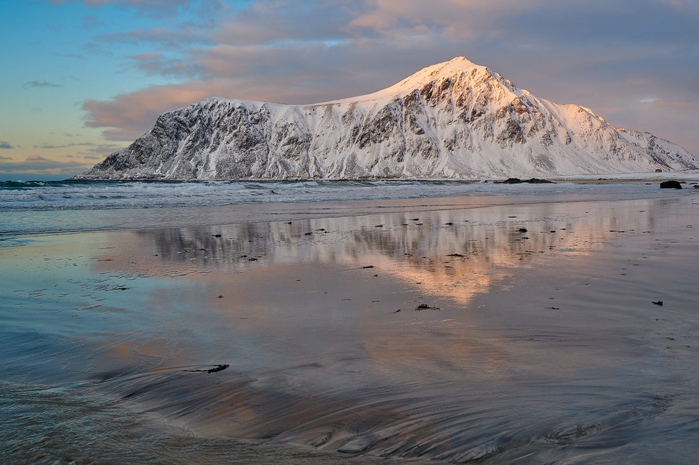
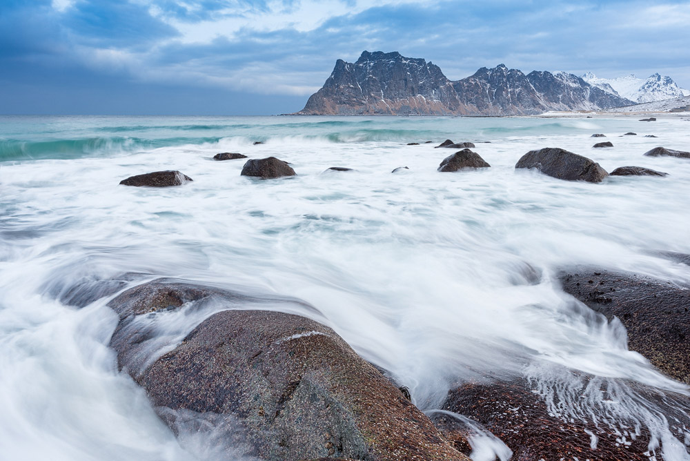
The Haukland Beach can be found on the north side of the island Vestvågøya, very close to the small town of Haukland. This beach, which is about 2 km long
and divided by a cliff, is one of the most beautiful beaches I have seen in person. The beach forms a
crescent shape and is characterized by its white, fine sand,
which one would not expect to find in the Lofoten. The beach is surrounded by steep walls and small mountains in the water. In addition, there is the turquoise, clear water which
encourages immediate jumping in, at least if you manage to ignore the water temperatures.

About 2 km north of Haukland Beach is Utakleiv Beach, another remarkable beach made of sand and rocks
(see map).
In recent years, it has been possible to drive directly to the beach from Haukland through a tunnel, avoiding the need to walk around the mountain "Veggen." If you want to drive
all the way to the beach, you have to pay a small fee of 20 NOK into a tin can. The rock cliffs provide many photo opportunities, but you should be very careful as the combination
of wet rocks and tiny algae can make them very slippery. Utakleiv offers many photo opportunities in the morning and evening and should not be missed on a Lofoten tour.
(back to the top)

The beach of Flakstad is located in the south of the Lofoten on the island of Flakstadøya and offers a particularly impressive setting in the evening
(see map).
The Flakstad Beach is probably a must-see for every tourist on the Lofoten, as the beach is located directly on the E10 on the route towards the southern part of the archipelago.
In the background of the beach, the southern side of the mountain Hustinden can be beautifully staged as a photo motif. If you follow the E10 about 2.5 km further south, you will
reach another
sandy beach located directly in the village
of Ramberg. The beach is located in a small bay and is about 1 km long.

The location of Vikten, in the southern part of the Lofoten Islands, can be reached from the north by driving through the 1780-meter-long Nappstraumen tunnel and following the E10
about 5 kilometers south of the tunnel
(see map).
Once you arrive at the location, there is a very small sandy beach to the west, which provides several beautiful photo opportunities with many smaller and larger rocks.
(back to the top)

If you drive south on the E10 until the end of the Lofoten Islands, the surroundings are characterized by steep, high cliffs and small fishing villages that
integrate into the rocky landscape. The string of small fishing villages starts with the tiny village of Hamnøya and continues with the villages of Olnilsøya, Sakrisøya, Reine,
Søvågen, and the southernmost village of Å. The villages are all located close together and are partly connected by bridges or small tunnels. So if you're looking for small, colorful
fishing huts, this is the perfect place. In the height of summer, there is, of course, a lot of tourist activity in this area, but in the off-season, strolling through the villages is
a real pleasure and highly recommended.
(back to the top)

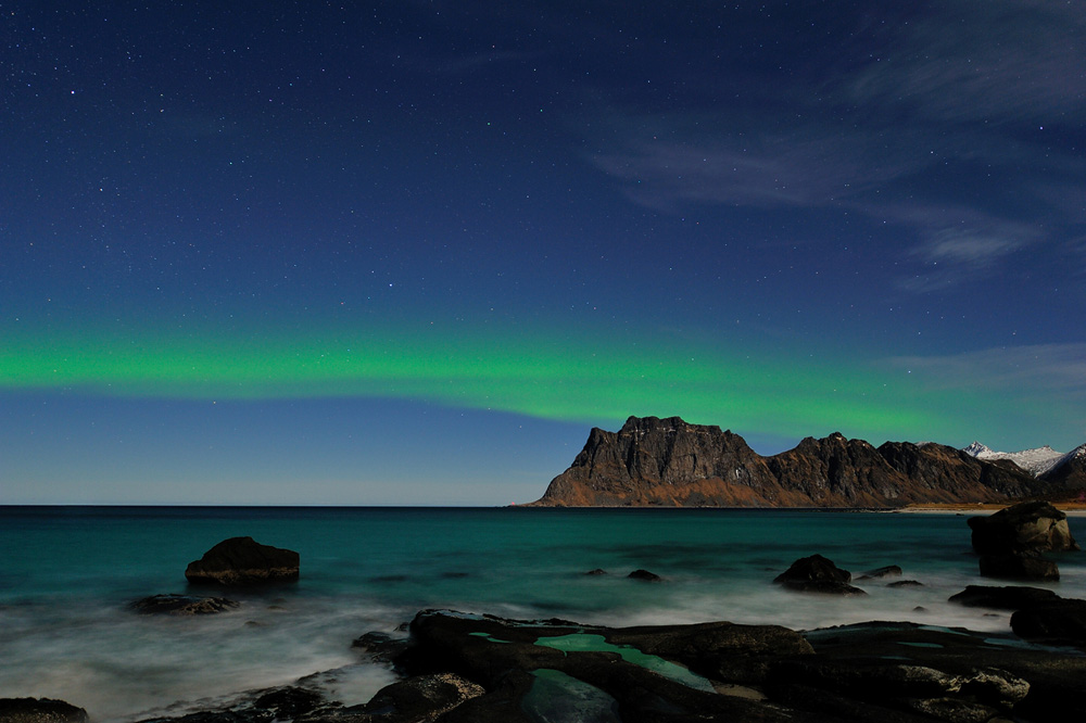
Spending your winter vacation about 200 km north of the Arctic Circle may cause some people to shake their heads in disbelief. However, anyone who has
experienced the winter landscapes of the Lofoten Islands will surely no longer be among those who shake their heads at the mention of the destination. It is widely believed that in
northern Norway, you never see the sun during the winter. In early February, for example, the sun rises at around 9:00 am and sets at around 3:30 pm. Including the twilight, you have
plenty of time to experience the Lofoten Islands in daylight. On clear nights, you also have the opportunity to go in search of the Northern Lights. Another advantage is the
temperatures. Generally, it is a bit colder on the Lofoten Islands than at the same time in Germany, but the Gulf Stream ensures moderate temperatures relative to the latitude of the
islands. So, it can also be quite mild with temperatures above freezing in winter.
By the way, if you want to experience
stockfish
in its fresh state, the best time to visit the Lofoten
Islands is at the beginning of the year, as the fish is already caught in January and fortunately doesn't have such a strong smell as it does later in the summer ;-)
(back to the top)
The Nordic countries are not a cheap travel destination, and unfortunately, this also applies to the Lofoten Islands. As I mentioned at the beginning of this travel report,
flying to the Lofoten Islands, especially for shorter stays, is my preferred choice. An economy class Lufthansa flight from Frankfurt via Oslo, Bodø, and a final landing in Svolvær
or Leknes costs around 600 euros per person. It becomes cheaper if you continue your journey to the Lofoten Islands by ferry from Bodø or choose the city of Narvik or Evenes on the
mainland as your destination airport. For the onward journey from Narvik (approx. 240 km) or Evenes (approx. 170 km) to the Lofoten Islands, you still need to factor in driving time
with a rental car until you finally reach Svolvær on the Lofoten Islands.

For a compact rental car from one of the well-known rental companies, one should budget around 500 euros per week in summer and around 400 euros in winter. The accommodation costs
depend heavily on the type of accommodation. Somewhat larger vacation homes can be obtained outside the main season (summer vacation) for as little as around 60 euros per day, which
can help reduce travel costs, especially if you are traveling as a couple, since you can largely cater for yourself and are not bound by any breakfast times, as may be the case with
other types of accommodation.
When shopping daily in Norway, one can feel the purchasing power of one euro is not more than 0.72 euros in Norway (source: OECD, as of April 2017). Therefore, for example, dining
out in Norway is noticeably more expensive than in Germany (about 30-40%). For groceries, I recommend shopping at larger supermarkets in the cities, as prices are significantly cheaper
than in smaller stores. Although Norway is a country with oil reserves, unfortunately, gasoline and diesel prices are still at the high German level. Finally, there is good news that
all roads, bridges, and tunnels are free of tolls.
(back to the top)
For landscape photography, one should plan to use focal lengths between 20mm to 200mm (based on full-frame). I would not want to do without a tripod under any circumstances. On the
one hand, a tripod helps with image composition, and on the other hand, interesting lighting conditions require long exposure times. Then, a set of different graduated filters should
not be missing, and a polarizing filter is also useful for many subjects. I have never done wildlife photography in the Lofoten Islands, but in general, as much focal length as
possible should be taken along.
Those who have visited the Lofoten Islands are very likely to plan future visits. The Lofoten Islands offer endless possibilities, especially for landscape photography. Although
getting there can be quite complicated, and the weather is typically Nordic, visitors are compensated with breathtakingly beautiful landscapes. The Lofoten Islands also offer plenty
of opportunities for wildlife photography. During my last trip to the Lofoten Islands, I had seven encounters with sea eagles within just one week. In the northern part of the Lofoten
Islands, close to Vesterålen, you have realistic chances of encountering moose. To photograph seabirds, the best places are the bird cliffs of Vedøya on Røst or Måstadheia on Væøy,
which are known for their richness in bird species and are considered one of the richest in the world. However, I cannot comment on the conditions at the bird cliffs since I have not
yet explored this part of the Lofoten Islands.
(back to the top)
Here you can download a map of the Lofoten. You will need a PDF reader to view and print it. I hope the map helps you to orient yourself a little on the Lofoten. However, I also
recommend buying a map of the Lofoten with a scale of 1:100,000. For those who want to hike on the Lofoten, I recommend the three partial maps of the Lofoten (Vågan, Vestvågøy, and
Vest-Lofoten) with a scale of 1:50,000 from "Turkart".
 Map of Lofoten
written: November 2012, (author: Olaf Juergens)
updated: March 2020
 print version


