- Location and arrival
- When does the heath bloom?
- Right in the middle, the Wilseder Berg
- The Totengrund
- The Büsenbachtal
- The Osterheide near Schneverdingen
- The equipment
- Conclusion
- Maps of Lüneburg Heath
The region of Lüneburg Heath is located in the northeast of Lower Saxony, between Hamburg and Hannover. The heath landscape consists of large, expansive heath areas and is mostly
a flat terrain, but also has some smaller or larger hills. The landscape is largely kept open by grazing with heath sheep (Heidschnucken).

More specifically, the Lüneburg Heath is divided into several natural areas. In my photographic travel report, I am focusing on the largest part (approximately
1286 km²) of the Lüneburg Heath, called the "Hohe Heide", or more precisely, the "Lüneburg Heath Nature Reserve". This nature park is roughly located between the cities of Soltau to
the south, Schneverdingen to the west, Buchholz to the north, and Bispingen to the east. In addition, the Lüneburg Heath also includes the South Heath Nature Park (north of Celle),
the East Heath (east of the city of Lüneburg), and the Uelzen Basin with the Luhe Heath, among other areas.
(back to the top)
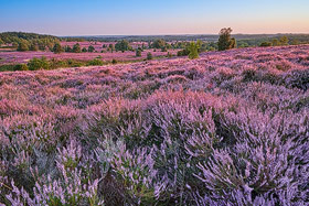
One of the most important questions is, of course, when is the most beautiful time to see the heath in bloom. According to a rough rule of thumb, the heath
typically blooms in the summer between August 8th and September 9th. However, this is only a general guideline, and depending on the weather, the bloom time may shift forward or backward
by a week or so. From my own experience, I can also say that the bloom on different fields within the same region can have very different patterns. So, while the heath on one field may
already be fading, the bloom a few kilometers away may be in full splendor. The Tourist Board provides a "Heath Blossom Barometer," which provides a good indication of the current state of the bloom:
click here
(back to the top)
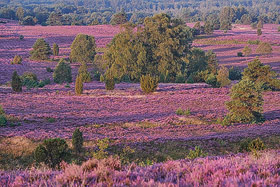
In terms of the Lüneburg Heath region, which is the focus of my report, the area around the Wilseder Berg is the absolute center of the heath. The Wilseder Berg (169m)
is more of a hill than a mountain, and offers a wonderful view of the heath landscape. For kilometers around the Wilseder Berg, the area is fortunately car-free, so the journey to the hill is
already the destination! There are different parking areas around the area, which lead to the hill after a more or less long hike. One of the quickest ways is from the southwest, starting from
the parking lot on Niederhaverbeck Landstraße (L211) to the Wilseder Berg
(
see also map).
(back to the top)
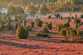
About 1 km southeast of Wilsede, you will come across the Totengrund
(
see also map).
The Totengrund can best be described as a basin, and it is definitely worth a visit early in the morning. Due to the basin location, the chance of encountering fog in the valley in the early
morning is very high. A circular path runs along the upper edge of the valley, giving you the freedom to choose between photographing backlit at sunrise or with the sun at your back. It is also
worth looking for motifs around the basin, as the heath landscape is also very beautiful here.
(back to the top)
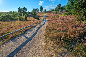
Another heath area that I would not like to leave unmentioned in this report is the Büsenbachtal near Handeloh
(
see also map). After a short walk along the
Büsenbach stream from the parking lot, you will be greeted by a wonderful, hilly landscape that is almost entirely covered with heather. The heath areas in the Büsenbachtal are not among the
largest heath landscapes in the area in terms of area, but they offer a charming backdrop due to their mountain and valley landscape.
(back to the top)
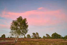
In the east of Schneverdingen is the Osterheide, which originated from a former military training ground and whose operations were stopped in the mid-90s. As the heathland
was extensively renatured, there is hardly any evidence of its former military use. The Osterheide is one of the largest heathlands in the region in terms of area
(
see also map). The heathland is largely flat
and to the south is the noteworthy
Pietzmoor, which can be
well explored via a circular trail.
(back to the top)
For landscape photography in the Lüneburg Heath, it is advisable to plan for focal lengths between 14mm and 200mm, and a macro lens can also be useful in the heath. Besides the landscapes,
of course, there is also wildlife, but from my experience, encounters with wild mammals in the heath were very rare, even though I often went out before sunrise or after sunset. I suspect that
the visitor pressure in many areas of the heath is so high that mammals rarely show themselves in the heavily frequented places. Of course, there is also the bird world, and anyone looking to
capture it will naturally need a larger focal length.
On the other hand, I would not want to do without a tripod in any case, as it is very helpful for image composition and is essential for achieving maximum image quality in low light conditions.
Also, graduated filters and neutral density filters are useful for many subjects. In addition to photo equipment, clothing should also be appropriate. Therefore, sturdy hiking boots with ankle
protection are definitely recommended.
The most exciting time to visit the Lüneburg Heath is certainly during the blooming of the heather. As this is a well-known travel time not only for photographers, it is recommended to book
accommodation well in advance! Unfortunately, it is impossible to predict exactly when the heather will reach its peak blooming time. If the heather is not fully bloomed, the area will appear
more greenish, and towards the end of the blooming season, the color will be more brownish. In addition to the optimal blooming time, good weather is also necessary for the colors of the heather
to shine in the sunlight. As you can see, this is a game with many unknowns, but perhaps that's what makes it so exciting and encourages a return visit.
(back to the top)
You can download a map of the Lüneburg Heath and the featured heathlands here. To view and print it, you will need a PDF reader. I hope the map helps you to get your bearings in the heath
a little.
 Map of Lüneburg Heath
written: December 2022, (author: Olaf Juergens)
 print version


